
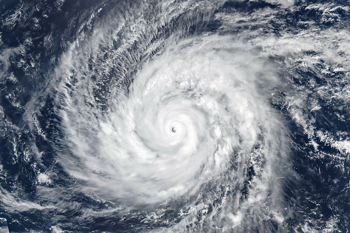
Explore Super Typhoon Sinlaku: Intensified rapidly, reaching category 5 status. Impact on Saipan and Tinian forecasted.
Overview of Super Typhoon Sinlaku
Super Typhoon Sinlaku intensified rapidly over the North Pacific Ocean in mid-April 2026, reaching exceptional strength as a category 5 storm just weeks into the season. NASA's Suomi NPP satellite captured an image on April 13 at approximately 03:30 UTC (1:30 p.m. local time), showcasing the storm’s intense structure and impact potential.
Storm Intensity and Impact
At the time of observation, Sinlaku carried sustained winds of about 280 kilometers per hour (175 miles per hour). This intensity places it in the most severe category on the Japan Meteorological Agency's scale, comparable to a category 5 storm under the Saffir-Simpson wind scale. Forecasters predicted that the storm would affect Saipan and Tinian with typhoon conditions from April 14 through April 15 before weakening to tropical storm strength.
Atmospheric Phenomena
Sinlaku's formation in the troposphere generated gravity waves visible much higher, even extending into the mesosphere. These atmospheric disturbances were captured by NASA’s VIIRS (Visible Infrared Imaging Radiometer Suite) on the NOAA-20 satellite. The resulting image displayed concentric waves illuminated by airglow.
Comparative Context
Super Typhoon Sinlaku marked a significant occurrence in early 2026, as it was the second category 5 tropical cyclone of that year after Horacio, which formed over the South Indian Ocean in late February. Meteorologists highlighted that Sinlaku is one of only a few category 5 typhoons on record to occur so early in the season.
Simultaneous Events
While Sinlaku was making headlines, other tropical cyclones were active across the globe. On April 10, Tropical Cyclone Maila crossed the equator while rotating in an opposite direction. Additionally, Tropical Cyclone Vaianu passed over New Zealand’s North Island on April 12.
Data Sources and Acknowledgements
The image was provided by NASA's Earth Observatory using VIIRS data from NASA EOSDIS LANCE, GIBS/Worldview, and the Suomi National Polar-orbiting Partnership. The story was prepared by Kathryn Hansen.
Source: Read Original Article
Post a Comment