
Satellite imagery shows extensive flooding along Colombia's Sinú River in Córdoba due to unusually heavy February rains, impacting farmland and communities
Floods in Northern Colombia’s Córdoba Department: An Unprecedented Event
February is typically a dry month in the Córdoba department of northern Colombia, a region known for its farming and cattle industries. However, in 2026, early February brought unusually heavy rains that dramatically altered local seasonal rhythms. NASA's Earth Observatory captured these changes through satellite imagery.
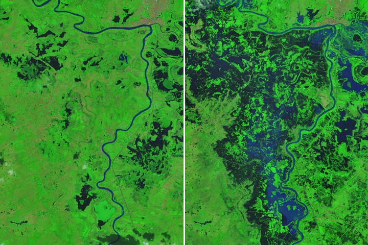
### Satellite Imagery Reveals Extent of Flooding
The Operational Land Imager (OLI) on Landsat 9 documented the flooding along the Sinú River on February 9, 2026. In false-color images (bands 7-5-4), dark floodwaters submerged farmland, pastureland, and several communities, particularly west of the river. The city of Lorica, with a population of approximately 90,000 people, can be seen in the upper part of the image.
### Precipitation Patterns Unveiled
Before these heavy rains, January had already been unusually wet. On February 1 and 2, an unusual cold front from the Caribbean moved southward, forcing moisture-laden air into northern Colombia and over the Andes. This led to several days of intense downpours, with some areas receiving more than 4 to 7 centimeters (2 to 3 inches) of rain per day.
According to analysis by NASA's Integrated Multi-satellite Retrievals for Global Precipitation Measurement (IMERG), rain rates near Lorica reached up to 1.7 centimeters per hour on February 1, the heaviest rainfall recorded during this period. The floods continued into mid-February, with imagery from NASA’s Terra satellite showing widespread flooding on February 25.
### Devastating Impact of Floods
The impact of these floods was extensive and destructive. More than 80 percent of Córdoba's area experienced flooding, as reported by the UN Office for the Coordination of Humanitarian Affairs. Preliminary estimates suggest that thousands of homes were destroyed, over 11,000 families were displaced, and more than 150,000 hectares of farmland were inundated.
NASA Earth Observatory images by Michala Garrison, using Landsat data from the U.S. Geological Survey. Story by Adam Voiland.
Source: Read Original Article
Post a Comment