
Explore the extensive ice coverage of the Chesapeake Bay during the severe winter of 1976-1977 using Landsat imagery. Discover how frozen conditions impact
Historical Winter of 1976-1977: A Time of Extensive Ice Coverage in Chesapeake Bay
February 7-8, 1977, marked a significant period during the severe winter of 1976-1977, which affected regions along the U.S. Mid-Atlantic coast. This winter was particularly notable for its widespread ice cover and prolonged cold temperatures that froze over parts of the Chesapeake Bay.
Landsat Imagery Reveals Extent of Ice Formation
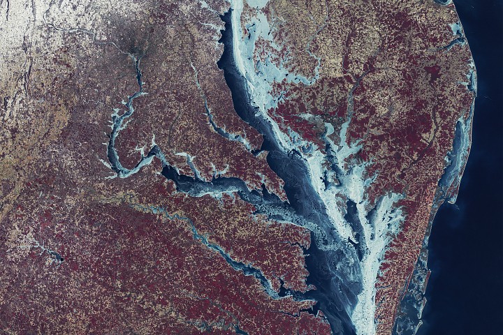
The Multispectral Scanner System (MSS) on board Landsat 1 captured a detailed image of the Chesapeake Bay's ice conditions during this period. The mosaic combines two images acquired on February 7 with another from February 8, presenting the landscape in false color to highlight different features: ice appears as shades of blue, green, and white; snow is shown in white; vegetation in red; and urban areas in brown-gray tones.
Detailed Analysis of Ice Conditions
According to a NASA analysis published in 1980, ice began forming in the Chesapeake Bay's upper tributaries by late December 1976. By mid-January 1977, it had spread to the middle section of the upper bay. The maximum extent of ice was observed one week into February, when approximately 85 percent of the bay was frozen over.
Persistent westerly winds at the start of February pushed the ice towards the eastern shores of the Chesapeake and Delaware bays, causing visible fractures on the surface. Calmer conditions allowed new ice to form in areas previously open water, creating thinner, darker blue patches.
Impact on Local Ecology and Economy
The deep freeze had significant impacts beyond the visual appearance of the bay. Ice and cold water led to high mortality rates among local shellfish populations. The weight of the shifting ice also caused damage to piers, marinas, and lighthouses along the coast.
In comparison, the winter of 2025-2026 saw less extensive ice coverage in the Chesapeake and Delaware bays. U.S. National Ice Center data showed about 38 percent coverage on February 9 and 10, with substantial ice concentrations in the upper bay and its tributaries.
Uncommon Winter Activities and Challenges
Despite the reduced extent of ice, winter activities such as ice boating remained possible in some areas. For example, ice boaters could race across the frozen Claiborne Cove on Maryland's Eastern Shore. However, these conditions also posed challenges for local watermen, trapping boats and limiting access to the bay.
Sources
NASA Earth Observatory image by Mike Taylor, Ginger Butcher, and Michala Garrison, using Landsat data from the U.S. Geological Survey.
Story by Kathryn Hansen.
Source: Read Original Article
Post a Comment